
The best wall maps for classrooms turn geography lessons into an always-visible learning resource. The right choice depends on your available wall space, students’ age, map detail needs, and how much daily handling the map will receive.
We compared classroom-friendly world and U.S. maps by size, readability, educational value, durability, and display flexibility so you can choose a practical fit for your learning environment.
Best 10 Wall Maps for Classrooms Picks for 2026
Best Overall

- Africa-centered projection keeps countries intact
- Laminated surface supports classroom use
- Topographical relief adds physical geography detail
Best For: Classrooms needing a durable, detailed world reference
Best for Early Learners
Kids' USA and World Map Poster Set
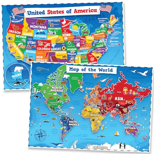
- Includes colorful U.S. and world map posters
- Waterproof, tear-resistant PVC construction
- Dry-erase compatible for interactive lessons
Best For: Preschool classrooms and early geography activities
Best Large-Format U.S. Map

- Measures 67 by 45 inches for room-wide visibility
- Covers states, territories, cities, and capitals
- Laminated surface supports dry-erase activities
Best For: Large classrooms teaching U.S. geography
Best Illustrated Option

- Color-coded continents support visual learning
- Features plants, animals, landmarks, and cultural icons
- Labels capitals, cities, and bodies of water
Best For: Child-focused classrooms and playrooms
Best Value Pair

- Includes world and USA maps
- 3 MIL laminated and tear resistant
- Compact 18-by-29-inch posters
Best For: Classrooms needing two durable reference maps
Best Oversized Display
Classic Elite Laminated World Map

- Large 36-by-48-inch classroom display
- Miller Projection limits polar distortion
- UV coating supports dry-erase use
Best For: Large rooms needing a prominent world map
Best Equal-Earth Design

- Equal Earth design shows true relative size
- Includes world and USA maps
- 3 MIL laminated and tear resistant
Best For: Projection lessons and everyday classroom reference
Best Dual-Map Set
Classic World and USA 3D Map Set

- Two 24-by-36-inch maps
- Laminated for dry-erase use
- 3D World and USA terrain relief
Best For: Classrooms needing both global and U.S. references
Best Large Classroom Display

- Oversized 32-by-50-inch format
- Vivid eight-color political design
- 3mil double-sided dry-erase lamination
Best For: Large classrooms needing a highly visible world map
Best Compact Outline Map
Blue Laminated World Map Poster

- Compact 18-by-29-inch format
- Blue blank world outline
- Laminated matte finish
Best For: Small classrooms and simple world geography displays
Best Overall – Classic Laminated World Map
For shoppers comparing wall maps for classrooms, the Rand McNally Classic Edition combines a polished antique-style appearance with practical reference details. Its large laminated surface, current political information, and Africa-centered projection make it useful for both everyday geography lessons and broader discussions of continents, countries, and global patterns.
Best For: Classrooms, offices, and learning spaces that need a durable, detailed world reference with decorative appeal.
Pros:
- Africa-centered projection shows every continent and country intact.
- Lamination resists scuffs, fingerprints, and dry-erase marker.
- Color-matched topographical relief highlights major physical features.
- Ships rolled in a sturdy tube to help prevent creases.
Cons:
- The antique-style design may be less engaging for very young children.
- Its 50-by-32-inch size requires a suitably wide wall area.
This is a strong all-purpose choice when accuracy, durability, and presentation matter equally. The projection and relief details add useful teaching value beyond simple classroom decoration.
Best for Early Learners – Kids' USA and World Map Poster Set
This two-piece USA and world map set is designed for young children, making it a friendly option among wall maps for classrooms serving preschool and early elementary learners. Bright colors, artist-drawn icons, and clear labeling support visual learning without making the layouts overly busy.
Best For: Preschools, daycares, playrooms, and homeschool spaces introducing toddlers and young children to geography.
Pros:
- Includes both U.S. and world maps for broader introductory learning.
- Illustrated icons help connect places with landmarks, animals, and cultural references.
- Waterproof, tear-resistant PVC material is made for repeated use.
- Surface can be written on with dry-erase markers and wiped clean.
Cons:
- The 24-by-16-inch size offers less detail than larger reference maps.
- Its early-learning focus may not meet the needs of advanced geography lessons.
Choose this set when approachability and interaction are more important than dense cartographic detail. The two-map format also lets teachers introduce national and global geography side by side.
Best Large-Format U.S. Map – Extra-Large Laminated USA Map
When visibility across a classroom is the priority, this extra-large U.S. map stands out among wall maps for classrooms. Measuring 67 inches wide by 45 inches high, it presents all 50 states, territories, cities, capitals, and selected geographic features on a reusable laminated surface.
Best For: Classrooms and offices that need a highly visible, write-on U.S. geography reference.
Pros:
- Extra-large format is easy to view from across a room.
- Includes all 50 states plus Alaska, Hawaii, and several territory insets.
- Shows capitals, major cities, places of interest, mountains, and rivers.
- Two-sided lamination makes it moisture-resistant and dry-erase compatible.
Cons:
- Its very large footprint requires substantial wall space.
- It focuses on the United States rather than world geography.
This is a practical pick for U.S. geography instruction, especially where students need to see labels from a distance. The rolled tube and reusable surface add convenience for long-term classroom use.
Best Illustrated Option – Kids' Illustrated World Map
For younger students who learn well through visual connections, the Rand McNally Kids’ Illustrated World Map offers an inviting alternative to purely technical wall maps for classrooms. Color-coded continents and playful illustrations introduce geography alongside plants, animals, landmarks, cultural icons, and historical references.
Best For: Children’s classrooms, bedrooms, and playrooms where geography should feel engaging and decorative.
Pros:
- Color-coded continents make the map approachable for children.
- Illustrations connect geography with native plants, animals, landmarks, and culture.
- Labels include capitals, major cities, and bodies of water.
- Heavy paper provides added durability and the map is suitable for framing.
Cons:
- The paper construction is less wipe-clean than a laminated map.
- Illustrations may leave less room for dense reference detail.
This map is best when curiosity and visual storytelling are central to the learning space. It provides enough core labeling for orientation while keeping the overall presentation child-friendly.
Best Value Pair – Laminated World & USA Map Set
For classrooms needing broad geographic coverage on a practical budget, this two-poster set combines a world map with a USA map. The 18-by-29-inch posters use 3 MIL lamination for added durability and tear resistance, making them a convenient option among wall maps for classrooms.
Best For: Classrooms that want matching world and U.S. maps in a compact, durable two-poster set.
Pros:
- Includes both world and USA map posters.
- 3 MIL lamination adds durability.
- Tear-resistant construction.
- 18-by-29-inch size fits a range of classroom wall spaces.
Cons:
- Smaller than oversized wall maps.
- Supplied notes do not specify dry-erase compatibility.
This set is a straightforward choice when versatility matters more than maximum display size. Having two coordinated maps also lets teachers place regional and global references in different areas of the room.
Best Oversized Display – Classic Elite Laminated World Map
When visibility across the room is the priority, this 36-by-48-inch world map provides an oversized teaching display. Its classic styling, rich color, Miller Projection, and labeled flags of the world make it a strong candidate among wall maps for classrooms.
Best For: Larger classrooms, libraries, and learning spaces that need one prominent world map.
Pros:
- Large 36-by-48-inch format is easy to view from a distance.
- Miller Projection reduces distortion near the poles.
- Two-sided UV coating is designed to stay flat and resist cracking or peeling.
- Dry-erase compatible for write-on and wipe-off use.
Cons:
- Its oversized format requires substantial wall space.
- Only dry-erase markers should be used on the gloss-coated surface.
- Provides a world map only, rather than a world-and-USA set.
This is the most display-oriented option in the group. Choose it when a single, detailed map with occasional dry-erase annotation is more useful than multiple smaller posters.
Best Equal-Earth Design – Laminated World & USA Map Set
This two-poster set pairs a world map using an Equal Earth design with a USA map, giving classrooms a visual reference that shows continents at their true relative size. Both 18-by-29-inch posters feature 3 MIL lamination and tear resistance, useful qualities for wall maps for classrooms.
Best For: Teachers who want a compact world-and-USA set with an equal-area world-map design.
Pros:
- Equal Earth design shows continents at true relative size.
- Includes both world and USA maps.
- 3 MIL lamination helps improve durability.
- Tear-resistant posters measure 18 by 29 inches.
Cons:
- Smaller than the 36-by-48-inch alternative.
- Supplied notes do not specify dry-erase compatibility.
The Equal Earth design makes this set especially appealing for lessons involving map projection and relative landmass. It offers the same practical two-map format as a standard classroom set while emphasizing a different way to represent the world.
Best Dual-Map Set – Classic World and USA 3D Map Set
For classrooms that need both global and U.S. coverage, this wall maps for classrooms set combines two 24-by-36-inch laminated maps. The political and topographic styling, 3D terrain relief, and dry-erase surface support visual reference and reusable annotation.
Best For: Classrooms, educational spaces, home offices, and businesses that want matching World and USA maps.
Pros:
- Includes both World and United States maps.
- Laminated surface is suitable for dry-erase use.
- Large 24-by-36-inch format with 3D visual terrain relief.
- Described as up to date for U.S. and world information.
Cons:
- The set requires space for displaying two separate maps.
- The supplied notes do not specify mounting hardware.
This is a practical choice when a classroom needs a coordinated pair rather than a single map. Its laminated finish adds flexibility for instruction, while the two-map format broadens geographic coverage.
Best Large Classroom Display – Swiftmaps 32 x 50 World Map
Swiftmaps 32" x 50" RMC Large World Wall Map Poster - Laminated Rolled (32x50 Signature World)
Check Price On AmazonThis oversized Swiftmaps world poster is designed for high-visibility display, making it a strong option among wall maps for classrooms. Its 32-by-50-inch format, vivid eight-color design, political details, and 3D terrain relief help make the map a prominent teaching reference.
Best For: Classrooms, offices, and boardrooms with enough wall space for a large world map.
Pros:
- Large 32-by-50-inch size for prominent viewing.
- Vivid eight-color political map with shaded blue oceans.
- Includes 3D visual terrain relief and current cities and boundaries as described.
- Heavy 36lb poster paper with durable 3mil double-sided dry-erase lamination.
Cons:
- Its large dimensions may not suit smaller classroom walls.
- The supplied notes identify it as a rolled poster, which may require careful setup for display.
Choose this model when visibility across the room matters most. The generous dimensions and dry-erase lamination make it useful as both a display piece and a reusable educational tool.
Best Compact Outline Map – Blue Laminated World Map Poster
This compact blue world outline poster offers a simpler format for classrooms seeking wall maps for classrooms without a large display footprint. Its 18-by-29-inch paper size and laminated finish make it a straightforward wall reference for world geography activities.
Best For: Smaller classrooms, study areas, and spaces needing a single compact world map.
Pros:
- Compact 18-by-29-inch paper size.
- Blue world map outline design provides a simple visual reference.
- Laminated finish adds a protective surface.
- Single-map format is easy to incorporate into smaller displays.
Cons:
- Smaller than the other supplied map options.
- The notes describe it as a blank outline poster, so it may provide less geographic detail.
- The supplied details do not specify dry-erase capability.
This is the most space-conscious option in the group. It fits classrooms that prefer a basic world outline over a large, detailed political or terrain map.
How We Picked the Best Wall Maps for Classrooms
We focused on maps that support instruction while remaining easy to display and read from across a classroom. Our comparison considered map scale, geographic detail, labeling, color contrast, educational features, finish, and mounting practicality. Laminated options received particular attention because they can better withstand frequent handling, cleaning, and repeated use than uncoated paper.
We also included a range of formats, from compact 18-by-29-inch map sets to extra-large U.S. and world maps. This makes it easier to match the map to a small tutoring room, standard classroom, homeschool space, or large shared learning area.
Quick Comparison
- Best for broad geography lessons: Large world maps with clear country labels and strong visual contrast.
- Best for U.S. studies: Oversized USA maps that provide room for state names, borders, capitals, and physical features.
- Best for younger students: Illustrated maps with approachable graphics and simplified visual information.
- Best value for multiple lessons: Two-map sets that pair a world map with a U.S. map.
- Best for frequent use: Laminated maps that are easier to wipe clean and less vulnerable to small tears.
Key Buying Factors for Wall Maps for Classrooms
Size and Viewing Distance
Choose a map large enough for students seated at the back of the room to read key labels. A 50-by-32-inch or larger map creates stronger visual impact, while 18-by-29-inch formats work well near desks, reading corners, or on crowded walls.
World-Map Projection and Accuracy
Map projections change how continents and countries appear. A traditional classroom map may prioritize familiarity, while an Equal Earth-style design presents continent sizes more proportionally. Consider whether the map is intended for basic orientation, geography instruction, or discussions about representation.
Durability and Installation
Laminated surfaces are generally the practical choice for busy classrooms. Check whether the map arrives rolled, whether a frame is included, and whether you will need poster rails, adhesive strips, clips, or a dedicated hanging system.
Labels, Detail, and Visual Clarity
More detail is not always better. Look for readable typography, distinct borders, balanced colors, and enough open space that the map does not become visually overwhelming. Flags, topography, capitals, and physical features can add instructional value when they remain legible.
Who Should Buy Which Wall Maps for Classrooms?
Teachers building a central geography display should prioritize a large laminated world map with readable labels. Classrooms covering both global and U.S. geography may get more flexibility from a two-map set. For younger learners, an illustrated children’s map can make location and cultural lessons more approachable. Homeschool families and small classrooms may prefer compact formats that fit above a desk or beside a bookshelf, while large schools and shared learning spaces should consider oversized maps that remain visible from a distance.
Before buying, measure the wall, identify the viewing distance, and decide whether the map will be used for daily reference, occasional lessons, or decoration. Those three details usually narrow the choices quickly.